The Two Wells at Gnarlbine
We passed through Gnarlbine on Sunday 25 October 2020.
The lesser known and lesser visited well just south of Gnarlbine Rock is not one of Hunt’s. It is, though, a beautiful example of the stonemason’s craft in building a dry stone well.
-
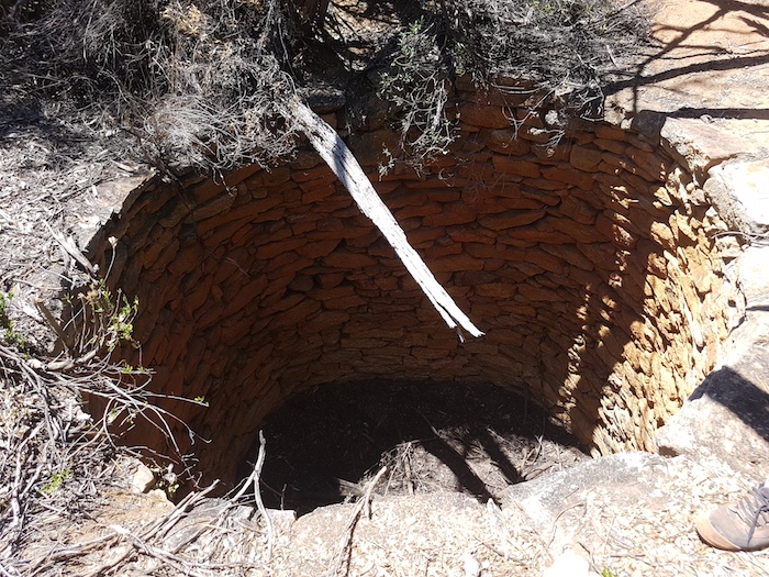
- The second well at Gnarlbine. It is not one of Hunts.
-
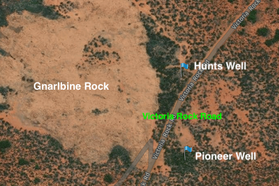
- The two wells at Gnarlbine
-

- Hunt’s Well at Gnarlbine.
-

- Hunt’s Well at Gnarlbine.
We left the second well, retraced our route on Victoria Rock Road north for a couple of kilometres and turned left onto a track that leads to a sand quarry. It also leads to the Hunt Track.
-

- The way around Gnarlbine Rock.
The historic Hunt Track leads into the west side of Gnarlbine Rock and is not accessible today. This sand quarry track allows access from the east side of Gnarlbine Rock to the west side and then onto the section of the Hunt Track that leads to Yerdanie.
[2021 Update: The Hunt Track from Gnarlbine East to Gnarlbine West has been opened up, obviating the drive around on the Sand Quarry Track – see more]
The Hunt Track
In June 2019, while re-creating Hunt Track from Gnarlbine to Yerdanie, Scott Wilson used satellite imagery to predict the presence of an historic woodline along the track about 5.7 kilometres east of the turnoff to the Prince of Wales mine. We drove to the where he thought the woodline would be, stopped the vehicle, walked a few paces into the scrub and immediately came across old spikes, cans, and tobacco tins. A few more paces into the bush there was evidence of railway sleepers and more artefacts – confirmation of Scott’s brilliant interpretation.
So on this Trip I decided to try to again re-locate this old woodline. It was an easier task than expected. Someone had created a ‘File Tree’ to mark where the woodline crossed the track.
-

- Salmon gum ‘File Tree’ sapling
-

- File Tree.
We had lunch at the Prince of Wales mine. Although abandoned, and risky for the unwary, it is subject to a number of active tenements, including gold and lithium.
-

- An angled entry to Prince of Wales mine.
The long Bigfoot camper trailer was difficult to manoeuvre through a stand of regrowth. Future travellers should now have no issues.

Yerdanie Rock and Well
The top of Yerdanie Rock provides great 360° views. Water from recent rains was pooled at the summit.
-

- Yerdanie cairn.
Hunt did not provide much information about his well at Yerdanie, other than stating it was on the west side of the rock. It has been ‘lost’ for more than 100 years, only recently being re-discovered. With the help of Corey’s drone we eventually located it.
-

- Hunt’s Well at Yerdanie.
-

- Hunt’s Well at Yerdanie.
The Hunt Track leads to Great Eastern Highway, seven kilometres distant from Yerdanie. There was no time to visit Woolgangie so we headed straight down the blacktop to Karalee.
Karalee
The sun was close to the horizon so there was time for only a flying visit at Karalee. The track west out of Karalee is overgrown and rough in places.
It was late in the day when we reached Morlining Rocks and selected a campsite.
Morlining Well
In the morning we walked to Morlining Well before continuing on the track to Yellowdine.
-

- Morlining Well
Diesel was cheap at Yellowdine (106 cents/L) so most took the opportunity to top up and inflate tyres to highway pressure.
Goldfields Road took us to the Rabbit Proof Fence Interpretive Site at Burracoppin and we then visited Hunt’s Well only a short distance west.
The Road Trip finished at Merredin.
© Kim Epton 2021
621 words, 17 photographs/images.
Terms of Use
Feel free to use any part of this document but please do the right thing and give attribution.