Dunn Track
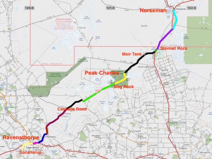
Dunn Track is a little-travelled track that traverses some very remote and rough country for 266 kilometres between Cocanarup and Norseman. Side trips to Northover Rockhole, Welcome Rockhole, Dog Rock, Moirs Rock, Stennet Rock and Dundas add another 18 kilometres.
Dunn Track’s reason for being was similar to the Holland Track that took prospectors from Broomehill to Coolgardie in the 1890s – it provided a shortcut to the Dundas Goldfields.
-
- Dunn Track
The Dunn Track starts at Cocanarup six kilometres east along Cocanarup Road from the South Coast Highway. Cocanarup Road was part of the South Coast Highway until 1959 when that major link road was realigned.
The Dunn family started sheep farming at Cocanarup, 20 kilometres east of present day Ravensthorpe in 1871 after James Dunn senior registered a ‘Free Run’ in 1868.
-

- Homestead at Cocanarup.
Surveyor General John Septimus Roe had explored through the area in 1848 and reported favourably on its prospects.
After James Dunn senior registered the Free Run his five sons and daughter started sheep farming at Cocanarup, 20 kilometres west of the present town of Ravensthorpe, in 1871, after George and John Dunn drove a flock from Albany. In 1873 the family was granted a permanent lease of 4,049 hectares (10,010 acres).
-

- Headstone at Cocanarup.
-

- Dunn brothers and sister.
The Dunn brothers pioneered a track from Cocanarup to the Moir’s property at Carlingup in the 1870s. When gold was found at Dundas in 1894 they extended their track to Peak Charles and Norseman.
At the same time Walter Dunn set up a store at Cocanarup to provide supplies to travellers going to the goldfields. The brothers transported goods overland from Hopetoun to Norseman. However, the distance was too far and the shop proved a failure.
In 1910 Guy May and Arthur Hewby explored extensively throughout the area and followed Dunn Track to the north east, making minor alterations.
Today’s Dunn Track passes through Ravensthorpe, crosses the Jerdacuttup River, and joins with Nindilbillup Road before passing through the Vermin Proof Fence near the Nindilbillup Creek.
It continues in a north-east direction across Cascade Road to Hewbey Swamp and Northover Rockhole. At this point to Track disappears and the traveller is forced to turn south-east onto a shotline. Two kilometres along this is another shotline that parallels the original track. For all practical purposes today, this is now Dunn Track. This shotline/track runs past Dog Rock, Peak Eleanora and on to Annes Pass.
The vegetation along the Track changes to the typical goldfields woodland on approach to Peak Charles. Peak Charles (651 metres) and the nearby Peak Eleanora stand out of the plain and can be seen up to 40 kilometres away. This part of the Track is in the Peak Charles National Park.
-

- Peak Charles
The summit of Peak Charles provides fantastic 360° views of the surrounding countryside. There is a two metre high rock cairn at the top.
The upright stone walls around Moir Rock harvest water into a tank on the southern side of the rock. W. Moir took out a lease on the area that included this rock in the late 1880s and the rock was subsequently named after him.
-

- Cairn at Moir Rock with Peak Charles in the background.
Stennet Rock has a rock wall to harvest rain water. The water is fed into a well-constructed turkey nest dam although this is now in a poor state. The rock is named after Thomas Stennet who prospected this area with Moir in 1892.
Dundas is an abandoned gold mining town 22 kilometres south of Norseman. Although all buildings have gone, the layout of the streets can be seen and occasional signs provide detail on the town.
The route of Dunn Track then parallels the Coolgardie-Esperance Highway into Norseman.
© Kim Epton 2020-2021
634 words.
See Terms of Use
Feel free to use any part of this document but please do the right thing and give attribution.