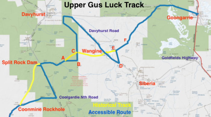
Gus Luck pushed through a track from Southern Cross to the 90 Mile, as Goongarrie was known at the time, in the 1890s to supply prospectors and miners at this early gold find. This re-constructed track with a few small re-alignments is today known as the Gus Luck Track.
The Track has totally disappeared between Southern Cross and Duladgin and, in any case, following it would be extremely problematic owing to the existence of a sturdy, north-south vermin proof fence that completely excludes access to the area. Between Coonmine Well and Goongarrie Nature Reserve only some sections of the Track can be driven, however, there are alternative routes.
-
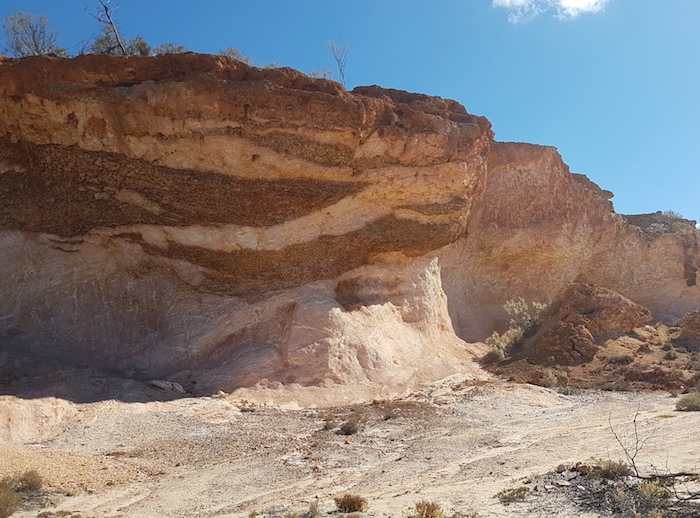
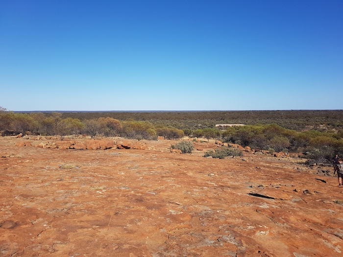
- Breakaway at Wongine, an important staging post on the Gus Luck Track..
For convenience, the Track today starts at Yellowdine and heads north to Weowanie, the first location on Luck’s original track. Weowanie is also part of Hunt Track pushed through in 1865-66.
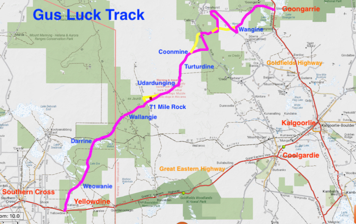
The Track
Yellowdine to Duladgin – 15 km
Fuel is available at Yellowdine Roadhouse.
The water harvesting complex for the Yellowdine Railway Dam is worth a visit. The drive past Yellowdine Rock emerges onto the main powerline track. Follow it for 800 metres and turn left onto the Marvel Lock-Yellowdine Road. This is a wide, dirt road that should be passable in all but an extreme rain event.
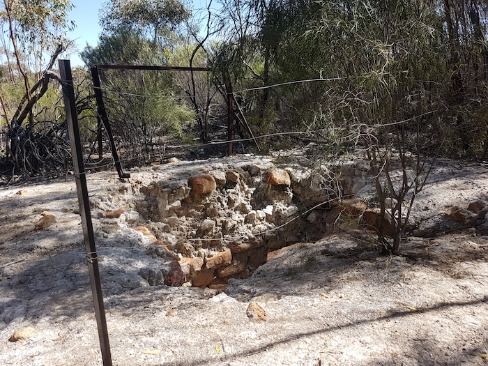
Just before the turnoff to Weowanie is Duladgin Well, a deteriorating construction by the Mines Department, circa 1900.
-

- Duladgin Well
Duladgin to Weowanie – 8 km
This section of the Track crosses the southern portion of Lake Seabrook. Much of it is very sandy when dry and may be impassable when wet.
A few hundred metres along the track is the signposted turnoff to a ‘lonely grave’ – that of a Scotsman, Thomas Davidson, who blew his brains out with a pistol on 28 May 1895.
-

- Thomas Davidson’s headstone.
Weowanie is part of Hunt Track.
-
- Hunt’s Tank at Weowanie Rock.
Weowanie to Darrine – 35 km
Just under two kilometres north-north-east of Weowanie the track runs into the Yellowdine State Barrier Fence. Go through the gate, turn right (heading south-east) and follow the fence for 700 metres to the Gus Luck Track on the left.
This Reserve is ex Jaurdi Station.
The fall of the country for the first few kilometres of this section of the Track is towards Eva Lake, a south-east extension of Lake Seabrook.
-

- The Gus Luck Track crosses Eva Lake.
Seven kilometres north of Eva Lake the effects of an extensive fire can be seen. This extends for about 12 kilometres north to Darrine Rockhole, located to the west of an unnamed lake, about 2.5 kilometres short of the Trans Australia Railway. The rockhole is to left of the Track just as it turns to the north-east.
-

- Darrine Rockhole
Past travellers have written their names on the covering of this waterhole and its lid, with some of the graffiti extending back to the mid 20th century.
There are no difficulties traversing this section of the Track.
Darrine to Ullambay (Willumbay) – 14 km
To the right, two hundred metres past Darrine Rockhole, are some cattle yards, a relict of the time when this country was Juardi Station.
Another 2.3 kilometres further on, turn right at the railway line and drive east for 1.9 kilometres to the crossing. Once over the railway continue east for 200 metres. Exercise caution as the track following the railway continues and Gus Luck Track to the left may be difficult to see.
Six kilometres along the Track, on the left, is a blazed kurrajong tree. This is reasonably easy to spot as it is the only kurrajong tree in the vicinity. The initials and year of the blaze can’t be determined.
-

- Blazed kurrajong tree.
Three kilometres further on is Ullambay Waterhole – covered with corrugated iron in the style of most of the rockholes along the Track.
-
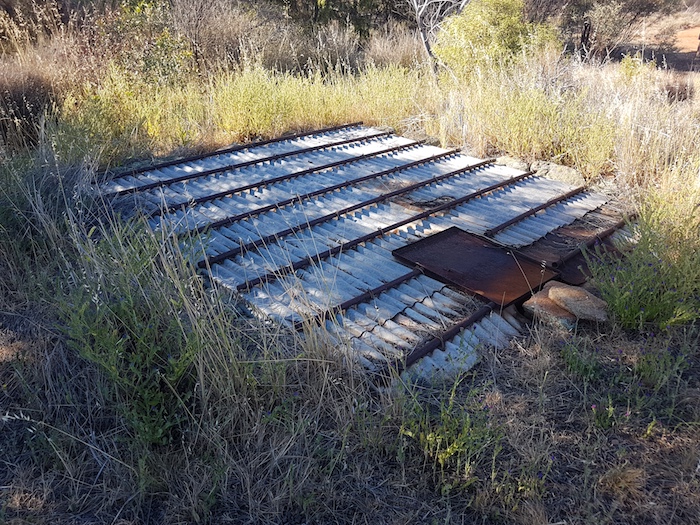
- Ullambay Rockhole
Ullambay (Willumbay) to Wallangie – 11 km
Two hundred metres into this section is a unnamed dam on the left, an abandoned and unmaintained Jaurdi Station relict.
The Track is easy to navigate/drive all the way through to Wallangie.
The grave of an unknown pioneer is on the right 200 metres before Ives Rock at Wallangie. The plaque on the grave reads:
“This unknown man died at this waterhole and was buried here by Albert Ives and son Len in year 1910”.
-

- This marker indicates the grave 20 metres off the Track to the right.
-

- Grave of an unknown pioneer at Wallangie.
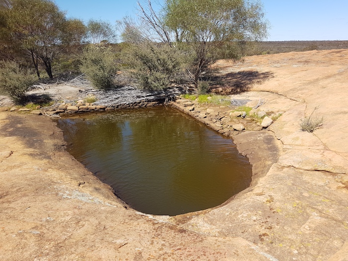
Wallangie Soak is situated at Ives Rock.
-

- Wallangie Soak
For many years Wallangie was known as Deadmans Soak, because of the nearby grave. The informant was Government Dogger Roly Dimer who had worked the region from 1957. It was gazetted as the centre of Water Reserve 3116 in 1896.
Nearby Pilaming Rock was shown as Deadmans Rock on maps from 1912, causing confusion between these two features.
Until 2005 Ives Rock was known as Ive Rock. Investigative work by Ian Elliot, noted bush historian, author of a number of books, developer of Hanns Track and long time contributor to Western 4WDriver caused the name to be corrected to Ives, the surname of the two men who buried an unknown man 200 metres to the west of the Rock.
-
- Ives Rock with Wallangie Dam in the background.
There are numerous tracks around Ives Rock, Wallangie Dam and Wallangie Soak. The track heading south from Wallangie eventually connects with the Trans Australia Railway. Easy to get confused.
-

- Wallangie Dam
There is a large dam at Wallangie, at which point the Track turns north.
Wallangie to 71 Mile Rock – 14 km
Eleven kilometres into this section the Track crosses a haul road servicing an open cut mine 27 kilometres to the north-west.
-
- Haul road to open cut mine 27 kilometres north-west.
Just over a kilometre from the haul road is a rocky patch. Protect your tyres. The turn into 71 Mile Rock is a further 2.4 kilometres further on. Easy to miss
The 500 metre drive into the rock is tight and rough. The track is narrow and overgrown. Turn left at the rock and drive 90 metres along the open space between the rock and the vegetation. An arrow fashioned from rocks points to the well.
-

- 71 Mile Rock
-

- ‘Rock arrow’ points the way to the well.
-

- Thickets hide the well.
-
- Windlass at the well.
-

- 71 Mile Well
71 Mile Well was also known as Deep Well.
71 Mile Rock to Udardunging – 32 km
Return to the main track and turn right. The track has been realigned and heads due east for 2.1 kilometres before turning due north. After 1200 metres it rejoins the original track.
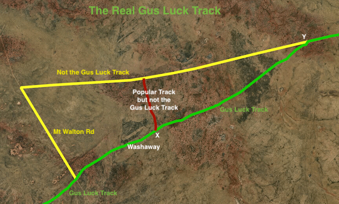
Cross the Mt Walton haul road 1.8 kilometres further on. It is at this point that some travellers go astray. The Gus Luck Track is straight on across the haul road. Do not turn left onto the haul road.
-
- Mount Walton Haul Road
About 2.4 kilometres after the haul road is a 150 metre long washaway that will require caution but should be able to be negotiated in 2WD in dry conditions.
-
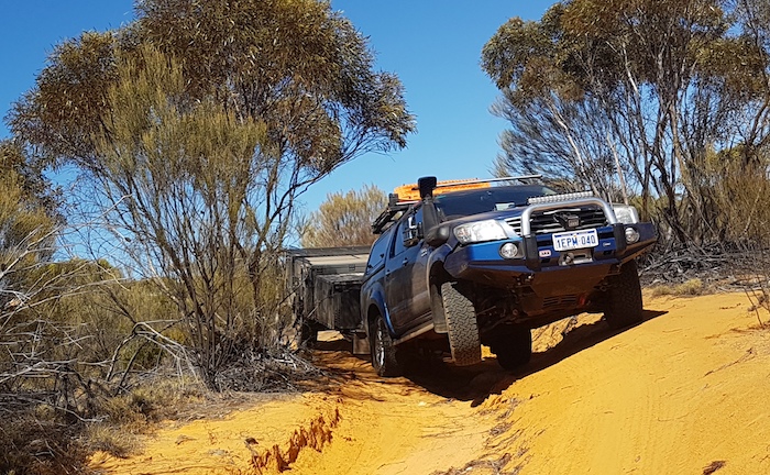
- Washaway two kilometres east of the Mount Walton haul road.
-
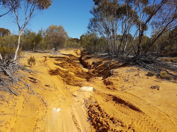
- Washaway
A further 300 metres on is another ‘Caution’.
Continue 1.1 kilometres to a Y junction (marked as X on the map below). Another dilemma for the purists. Gus Luck Track is straight ahead but it is clearly little used. Most traffic swings to the left and travels just over two kilometres to a good track that, if one turned left, joins the Mount Walton haul road. Turning right, of course, takes the traveller back to the Gus Luck Track (after eight kilometres).
-

- The real Gus Luck Track is straight ahead but most people bear left.
For those who choose to stay on the Gus Luck Track at the Y junction the track is little used and somewhat overgrown. After 7.3 kilometres the track is obliterated by large fallen trees. Pick up wheel tracks heading to the north and drive 200 metres to the good track referred to above. Turn right and drive one kilometre along this track to reconnect with the Gus Luck Track (marked as Y on the map below).
-

- Track between Urdardunging and 71 Mile Rock.
Evidence of an extensive and severe wildfire is seen 2.5 kilometres further on. This past fireground extends 10 kilometres, nearly to Pilarning Rock.
-

- Regrowth after an extensive fire.
After Pilarning the Track turns north for 1.5 kilometres to Udardunging Gnamma.
-

- Urdandunging Soak
Until 1965 official records mistakenly considered Udardunging to be the same location as Turturdine, however, locally it was known as Dookie Rock.
The name was recorded by explorer/surveyor Alexander Forrest in 1876.
Udardunging to Turturdine 9 km
Three hundred metres north of Udardunging the track tightens. One hundred metres further on, bear left at a Y junction.
This section is relatively straight forward driving and navigation.
Nearanging Rockhole is located well off the track to the left, half a kilometre before Turturdine.
-

- Nearanging Well
Turturdine has a number of interesting items to check out. The Rockhole, though reasonably well signed, is concealed by vegetation and its location is not immediately obvious.
-
- Sign pointing to Turturdine Well.
-

- Arrow made from rocks indicates the direction to the Well.
-
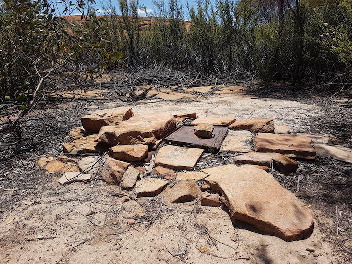
- Turturdine Rockhole is hidden in the fringing vegetation. A sign on on a post points towards it and, closer, an arrow formed by rocks indicates its position.
Rocks at Turturdine have numerous etchings, mainly made by various Dimers. With the passage of time this graffiti will no doubt be construed to be of historical nature.
-
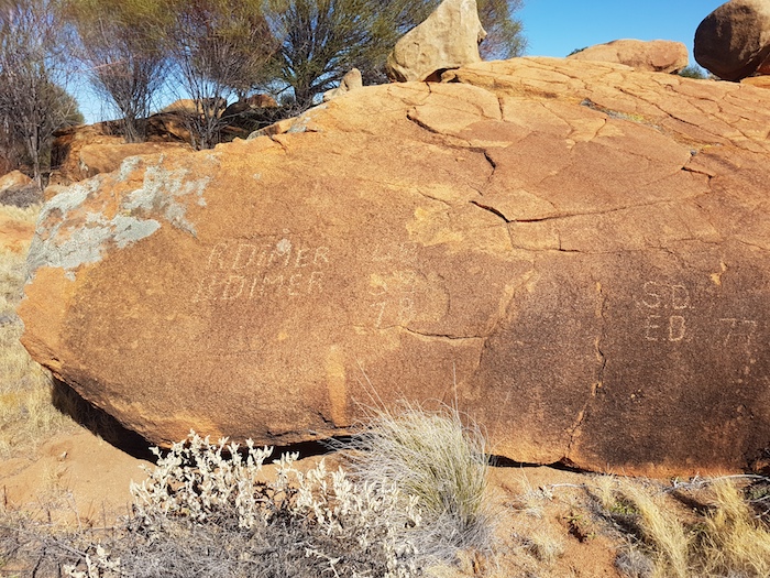
- Modern day etchings at Turturdine Rock.
A plaque commemorating Gus Luck is located at the base of Turturdine Rock and a cairn and survey marker sits at the top.
-
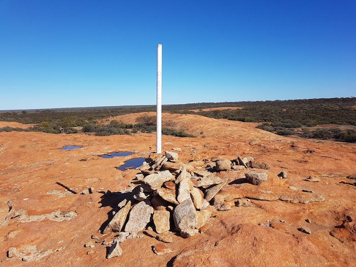
- Cairn atop Turturdine Rock.
Turturdine to Coonmine 16 km
Just over a kilometre after leaving Turturdine the Track tightens. At the six kilometre mark keep right at the Y junction. Midway through this section the track is narrow and tight in a number of places.
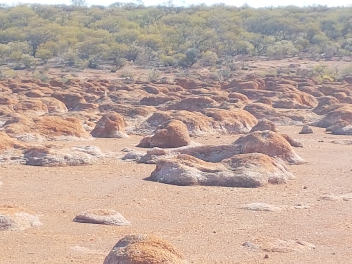
The are a number of capped bore holes along the Track to Coonmine.
-
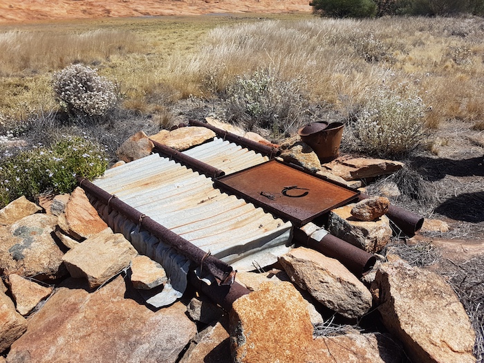
- Coonmine Rockhole
Coonmine was also known as Frost Soak, after an early prospector Billy Frost.
Coonmine to Split Rock Dam – 13 km
The historical track between these two points has been lost.
Coonmine to Coolgardie North Road – 12 km
This section is not part of the original Track and is merely a liaison to get to Coolgardie North Road.
Coolgardie North Road to Split Rock Dam – 13 km
This section is not part of the original Track and is merely a liaison to get to Split Rock Dam.
Coolgardie North Road is a good, high speed, dirt road.
Split Rock Dam to Point A – 10 km
This is an old track through previous station country. Slightly overgrown.
At ‘Point A’ the historical track continues north-east (see map), however, it is impassable and travellers need to stay on the eastward track along an old fenceline. This track ends just over a kilometre later at a well defined north south track (Point B). Turn left (north) and drive for 2.6 kilometres to pick up the Gus Luck Track on the left and the right. For convenience this is termed Point C.
Point A to Point C – 5 km
The historical track between these two points has been lost.
Point C to Wangine – 9 km
The historical track between these two points is still visible, however, it is too overgrown to follow in a vehicle. Those who choose to walk the nine kilometres to the historic staging post at Wangine will be confronted with dense thickets, some open country and numerous artefacts left by travellers past.
The alternative to get to Wangine by vehicle is to continue north, then north-west, then north 15 kilometres to Davyhurst Road. This is a wide dirt road with a good surface that leads south-east back to Wangine – a detour that totals 34 kilometres.
-

- The track west from Wangine disappears.
Wangine was an important staging post on the Track. The Wangine Hotel that had catered for travellers and teams on the Southern Cross to Goongarrie Track was shifted 15 kilometres south-east to Siberia in 1902.
-
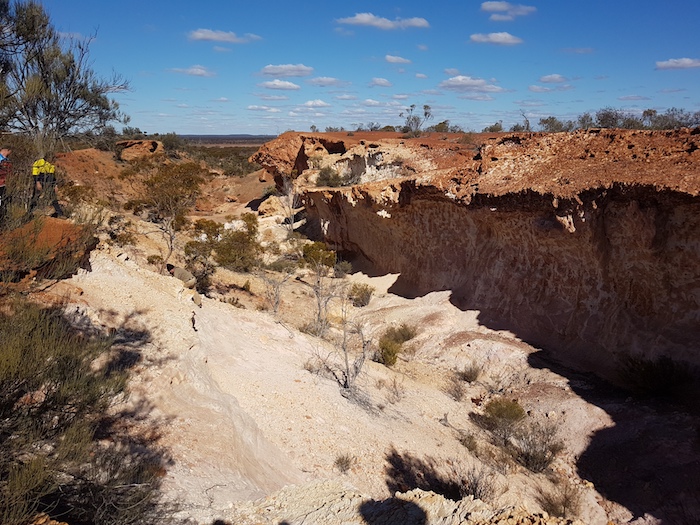
- Ravine at Wangine.
-

- Creek in the breakaway.
-
- Bungle-Bungle-like rock formation above the breakaway at Wangine.
-

- Breakaway at Wangine.
The name Wangine was recorded by surveyor G.D. Robinson in 1897.
Wangine to Pipeline Track (Point E) – 4 km
The historical track between these two points has been lost.
Wangine to Point D to Point E – 10 km
This section is not part of the original Track and is just a liaison to get to Point E.
Pipeline Track (Point E) to Lower Goongarrie (Point F) – 5 km
Locate the original Track by driving north on the pipeline to Point E. It should be reasonably obvious.
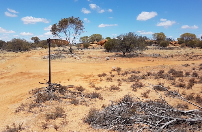
This section is very overgrown and indistinct in some places but it is definitely passable. At the 3.5 kilometre mark the track has been realigned (will not be noticed) and a kilometre later intersects perpendicularly with an old station track. Turn left and drive 500 metres to pick up the Gus Luck Track at the entrance to Goongoorie Station (Point F). Turn right at the sign and continue on the Track.
-

- South-western boundary of Goongarie Station, now controlled by DEC.
Lower Goongarrie to Goongarrie – 30 km
A creek crossing 3.6 kilometres into this section should be relatively easy for all vehicles including those towing camper trailers, except if it is flowing.
-
- Through creek.
The track is generally open and not too rough. except for a number of short, white rock sections approaching the Goongarrie Station homestead road. Once on this homestead road (turn right), the last eight kilometres to the now abandoned townsite of Goongarrie is easy travelling.
-

- The track to Lower Goongarrie.
The Gus Luck Track Track finishes at Goongarrie on the Goldfields Highway. Note that other sources suggest that the Track finishes at Menzies (see below).
How The Track Was Made
Luck asked Warden Finnerty at Coolgardie for assistance in getting recompensed for his efforts:
“… I thought that I would go and see Warden Finnerty about recompense for opening the track from the 90 Mile to Southern Cross. When I got there Finnerty was lying down on a bunk in his tent. I asked him politely if he could spare few me a few minutes. This he granted. I told him I had given the plans and directions to the Water Supply officers. I had hardly got the words out of my mouth when he jumped up and said “Go, I will have nothing to do with it. Why didn’t you come to me? I am the man you should have come to. I have nothing to do with it”.
“But” I said – I had known Finnerty before – “I ask you as man to man, what I am to do about it?”
He lay back on his bunk and said “Excuse me. I have had a bad morning and have a headache. If you make out the plan and directions again and send them to me I will see what I can for you.”
I expressed my sorrow to have disturbed him and hoped he would soon be alright.
In her book Westward Gold, H.H. Wilson noted:
“… Later he sent the map to the Water Supply Department for monetary reward. Not only was it refused, but the map was never returned. However, much later the new road followed the map.”
Billy Frost and Jack Bennett discovered gold at Goongarrie in early 1893 – before gold was discovered at Kalgoorlie in June 1893. Goongarrie was originally called the ‘Roaring Gimlet’ and then the ’90 Mile’ (the distance from Coolgardie). The development of a track from Southern Cross, the last place of ‘civilisation’ on the way to the goldfields, to Goongarie was inevitable.
Luck’s Track from Southern Cross to Goongarrie (or Menzies) would have had little use after the Kalgoorlie Menzies railway was completed in 1898.
Biographical Notes
Augustus Jules Luck (de Luc) was an explorer and gold prospector in Western Australia in the late 19th century.
-
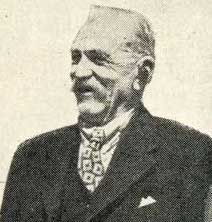
- Gus Luck in 1946.
It is believed that Luck was born on 23 May 1867 in Alsace, France to Jacques de Luc, a government employee, and Eve Hunsicker. It is not known when he arrived in Australia although he records that he was in Melbourne in early 1888. He is believed to have been a Legionnaire, however, Carnegie writes of him as being in the French Navy.
There exists a photo of him as a private in ‘A’ company, 1st. Battalion, Victorian Rifles in 1887.
Luck is credited with teaching explorer David Wynford Carnegie the bushmanship that enabled him to lead his expedition from Coolgardie to Halls Creek and return (1896–97), a journey of over 5000 kilometres and thirteen months in the desert which Carnegie describes in his book Spinifex and Sand.
-
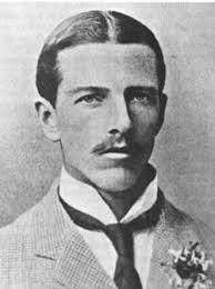
- David Wynford Carnegie
Luck wrote of his life and experiences in the bush between the1880s and 1930s in a book titled The Outback Trail. It is a fascinating story of camels, natives, prospecting, people, and more.
Due to his experience with camels in Algeria he was recruited for a survey and exploration for the Land and Railway Company in 1888. The expedition landed at Eucla and explored a little-known section of country north of Madura. After the expedition Luck returned to Melbourne where he became a corporal in ‘E’ company 2nd Battalion before again heading west. He spent time with a survey company around Perth. In 1891 he headed to Adelaide to collect 23 camels for a foray into the newly discovered goldfields at Southern Cross. He spent the next few years knocking around the goldfields cutting sandalwood, prospecting and transporting goods.
In 1894 he teamed up with David Carnegie to explore and prospect eastward of Coolgardie. Setting off with three months provisions on 26 March they travelled through the Hampton Plains Lands to Queen Victoria Spring, then northward to Mount Luck and Mount Shenton, before heading south west to Red Flag, Mulline and Coolgardie.
In appreciation, Carnegie presented Luck with a compass inscribed ‘From D.W. Carnegie, July 1894’. It was one of Luck’s most treasured possessions.
While preparing for the Expedition to Halls Creek and return Carnegie asked Luck to join him, Luck was unable to accept the invitation because he had already signed up with another company.
After his work with Carnegie, Luck went back to Victoria and married Emma Bees at Footscary. He was 27. He returned to WA and worked as a loco driver on the Perseverance Mine at Boulder. After leaving the goldfields he took up a farm at Southern Cross. He later built a house in Victoria Park that was resumed for construction of the Causeway Bridge.
Mount Luck in the Great Victoria Desert (28°50’32.21″S 123°29’54.23″E) was discovered and named by David Carnegie on 27 April 1894. It is possible but not confirmed that Luck Range, situated on Christmas Creek Station in the Kimberley south of the Great Northern Highway about 100 kilometres south-south-east of Fitzroy Crossing, was named after him.
Luck died on 13 August 1958 and was buried at Kalgoorlie.
Other Possible Routes
Other routes have been suggested for the Gus Luck Track. In Westward Gold, Wilson suggested:
“He surveyed roughly the track between Southern Cross and Menzies, a distance of 150 miles, having to cut scrub part of the way to allow his camels to get through.”
The High Beach website offers a number of alternatives and provides a lot of information about Luck and his Track. Among a number of postulates it states:
On a map prepared by Carnegie to accompany the report on his famous 1896 – 1897 expedition from Coolgardie to Halls Creek and return he marked the track of the 1894 excursion with words ‘Carnegie and Luck 1894’. On this trip Gus Luck carved ‘A.J. Luck’ in a rock at Mt Shenton.
The 1894 excursion started on March 24 from Kurnalpi, travelled eastward to Queen Victoria Spring, then north to Mt Venn and Mt Shenton, and then meandered south westerly to end at the Mt Margaret mining centre.
This Carnegie-Luck prospecting expedition covered 1357 kilometres over 90 days without finding any gold and was under the leadership of Carnegie, financed by the Hampton Plains Land & Railway Syndicate, and as described by the man himself, clearly not any part of the Gus Luck Track.
The full text of Carnegie’s Report of that expedition is in the Western Australian Explorers Diaries Project volume titled Unfinished Ambition.
References:
Landgate, Geonoma.
Scott Wilson, Eastern Goldfields Historical Society.
Luck, A.J., The Outback Trail, Hesperian Press, Carlisle 1981, p61.
Wilson, H.H., Westward Gold, Rigby, Adelaide, 1973.
Bridge, Peter, Biographical Notes in The Outback Trail, pvii
Carnegie, D.W., Unfinished Ambition, Hesperian Press, 2021.
Further Reading:
The War Cry (Salvation Army’s newspaper), 16 December 1893.
For details of other, lesser-known tracks, go here.
© Kim Epton 2020-2022
3385 words, 42 photographs/images
See Terms of Use
Feel free to use any part of this document but please do the right thing and give attribution.